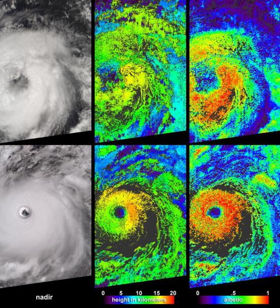
Cloud-top radiance and height characteristics of Hurricane Isabel are depicted in these data products and animations from the Multi-angle Imaging SpectroRadiometer (MISR). Isabel was upgraded to hurricane status a few hours after the top image panels in this set were acquired on September 7, 2003. By the time the bottom panels were acquired on September 11, Isabel was a strengthening category 4 hurricane, centered about 900 kilometers east-northeast of the Leeward Islands.
Cloud-top radiance and height characteristics of Hurricane Isabel are depicted in these data products and animations from the Multi-angle Imaging SpectroRadiometer (MISR). Isabel was upgraded to hurricane status a few hours after the top image panels in this set were acquired on September 7, 2003. By the time the bottom panels were acquired on September 11, Isabel was a strengthening category 4 hurricane, centered about 900 kilometers east-northeast of the Leeward Islands.
I remember the worn out book I received at the beginning of the
year and the occasional "bonus" video. It often seemed the
class highlights included finding out who had the "cool kids" books
from previous years and who could pick out the most outdated
reference in the video.
Some opportunities we have to help students understand the world
around us are very cool. Today, we have tech-stuff that can drive
home a higher level of understanding with very few wasted minutes
in preparation and presentation. Included are just two
satellite images that teachers use to show different pieces of
nature's puzzle. One thing that I look at differently now is
the height in which hurricanes are formed. I have to admit
that I had a two-dimensional view of hurricanes before using these
maps.
More stuff to come.
Large plumes of smoke rising from devastating wildfires burning near Los Angeles and San Diego on Sunday, October 26, 2003, are highlighted in this set of images from the Multi-angle Imaging SpectroRadiometer (MISR). These images include a natural color view from MISR's nadir camera (left) and an automated stereo height retrieval (right). The tops of the smoke plumes range in altitude from 500 - 3000 meters, and the stereo retrieval clearly differentiates the smoke from patches of high-altitude cirrus. Plumes are apparent from fires burning near the California-Mexico border, San Diego, Camp Pendleton, the foothills of the San Bernardino Mountains, and in and around Simi Valley. The majority of the smoke is coming from the fires near San Diego and the San Bernardino Mountains.
Large plumes of smoke rising from devastating wildfires burning near Los Angeles and San Diego on Sunday, October 26, 2003, are highlighted in this set of images from the Multi-angle Imaging SpectroRadiometer (MISR). These images include a natural color view from MISR's nadir camera (left) and an automated stereo height retrieval (right). The tops of the smoke plumes range in altitude from 500 - 3000 meters, and the stereo retrieval clearly differentiates the smoke from patches of high-altitude cirrus. Plumes are apparent from fires burning near the California-Mexico border, San Diego, Camp Pendleton, the foothills of the San Bernardino Mountains, and in and around Simi Valley. The majority of the smoke is coming from the fires near San Diego and the San Bernardino Mountains.

 Launch the media gallery 1 player
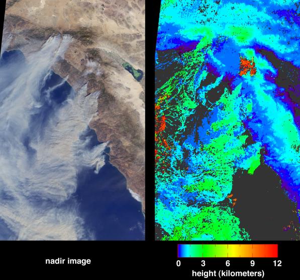 Launch the media gallery 2 player